 |
 n 2008, the North Cascades National Park (NCNP) climbing ranger program
marked its 25th year. Significant changes have taken place in that time.
Budget cuts in the 1990’s significantly reduced ranger staffing
levels, but better patrol management and more experienced staff have kept
the wilderness district effective and efficient. Under the leadership of
District Ranger Kelly Bush, the search and rescue helicopter short-haul
program has been firmly established at this park. Three years ago, the
NCNP was approved for helicopter short-haul rescues, enabling rangers to
rescue hikers and climbers from remote and hard-to-reach places in
minutes or hours instead of days. These faster rescues maximize the
chances that injured parties can receive prompt medical care to help save
life and limb.
Climbing Statistics
In the past seven years visitation to ten cross-country zones has been
tracked based on overnight permits issued. For the purpose of
permitting, quota allocation, and collecting data, North Cascades
National Park is divided into trail segments and two types of
cross-country zones. Trail segments have established campsites and
maintained trails while cross-country zones are left undeveloped and
pristine. These management classes were established in the park’s
first Wilderness Management Plan. Cross-country zone size and quota
allocation was determined by a variety of factors such as historical use,
potential for impacts in the area, remoteness, and the need to meet the
mandates of the Wilderness Act.
The table below (showing the number of registered backcountry users,
not the number of parties) reveals some interesting developments for the
2008 climbing season. The most noteworthy change was the relative
increase in the number of climbers going into the Terror Basin and
Sulphide Glacier cross-country zones. Boston Basin, Eldorado, Klawatti
and Logan cross-country zones showed a decrease in overnight users.
Overall, 2008 was the second lowest year in overnight backcountry use,
with only a small increase over 2007.
| |
2002 |
2003 |
2004 |
2005 |
2006 |
2007 |
2008 |
| Boston Basin |
628 |
631 |
668 |
630 |
629 |
542 |
481 |
| Colonial |
104 |
47 |
36 |
87 |
47 |
81 |
86 |
| Eldorado |
493 |
435 |
467 |
359 |
500 |
498 |
449 |
| Goode |
51 |
75 |
21 |
17 |
35 |
18 |
21 |
| Klawatti |
94 |
86 |
44 |
28 |
55 |
75 |
59 |
| Logan |
56 |
57 |
26 |
27 |
43 |
60 |
41 |
| Sahale Glacier |
517 |
617 |
415 |
613 |
514 |
374 |
431 |
| Sulphide Glacier |
638 |
607 |
685 |
628 |
530 |
463 |
657 |
| Terror Basin |
45 |
55 |
36 |
56 |
81 |
52 |
96 |
| Triumph Col |
68 |
66 |
61 |
46 |
75 |
51 |
54 |
| Totals |
2694 |
2676 |
2459 |
2491 |
2509 |
2214 |
2375 |
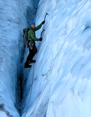
 Ice climbing on Mount Shuksan. Photo © Chris Kouba. |
|
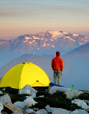
 Camp on Teebone Ridge. Photo © David Svilar. |
|
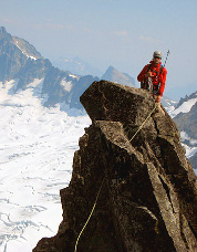
 Rock climbing on Forbidden Peak. Photo © Troy Rutledge. |
| Ice climbing on Mount Shuksan. Photo © Chris Kouba. |
|
Camp on Teebone Ridge. Photo © David Svilar. |
|
Rock climbing on Forbidden Peak. Photo © Troy Rutledge. |
Staffing and Patrols
In 2016, the National Park Service (NPS) will celebrate its 100th
anniversary. Using funding from the NPS Centennial Challenge Initiative,
the Wilderness District was able to hire one new seasonal ranger,
bringing the total number to 16 rangers. One permanent, one term, 10
seasonal, and four SCA (Student Conservation Association) rangers
conducted 145 patrols of trails and cross-country zones for a combined
total of 369 patrol days.
Impact Monitoring
An important patrol objective is the monitoring and documentation of
physical impacts from recreation and other sources in the wilderness.
This is especially true for cross-country areas that have recently
experienced a marked increase in popularity. The route into Terror Basin
is prime example. While a decade ago map reading, navigation skills, and
sheer determination were essential for reaching this remote area, in
recent years a well established route has been developed. As part of
their patrol objectives, wilderness rangers have documented routes and
camps developed by climbers in cross-country zones. In 2008, the
Wilderness District funded one ranger position with the goal of
documenting physical impact in six separate cross-country zones.
Utilizing GIS mapping technology and rapid site approach to collect data,
the ranger was able to survey routes and sites at Mount Blum, Torment
Basin, Crescent Creek, Ruby Mountain, Trapper Lake and Stout Lake. The
new findings will help rangers monitor future changes to these and other
sites.
Voluntary Climbing Register
The voluntary climbing register program has been used for over 30 years
at NCNP. Distinct from the required backcountry permit, the climbing
register is offered for (primarily) mountaineering parties to register
for a trip, leave information about destinations, expected return date,
and contacts for further information and emergency notification. This
year discussion in underway to evaluate whether the climbing register
should continue to be offered, or discontinued. Changes in the methods
of rescue activation (cell and satellite phones primarily) have caused
the register to be less useful.
In 2008, 352 parties filled out the voluntary climbing register form
at one of the ranger stations. Of those, 15 were incomplete, lacking
important information on time of return and/or routes to be climbed.
Roughly one third left out information important for rescue operations,
such as an emergency contact person. Fourteen parties did not check back
after completing their trips. Despite these shortcomings, the program
and its costs are deemed to be justified if even one rescue initiated for
an overdue party results in a life saved.
Marijuana Growing Operation
Given the ruggedness of North Cascades terrain, the discovery of a
marijuana growing operation in the North Cascades National Park Complex
was a surprise to park staff. A helicopter flying through the Ross Lake
Recreational Area spotted rows of plants high off the East Bank trail
that looked inconsistent with natural vegetation. Further investigation
revealed five marijuana growing plots totaling 4.7 acres. This was a
first for a National Park in the state of Washington. Federal and State
law enforcement officers raided the sites and destroyed 16,742 plants
with a street value of over $48 million dollars. Park resource damage
was caused by terracing of steep terrain, cutting trees, building fences,
spreading of chemical fertilizers, herbicides and pesticides, installing
wildlife traps, impounding creeks and installing irrigation systems, and
building living quarters and areas of human waste. Over 1000 pounds of
garbage was flown and hiked out. According to NCNP plant ecologist
Mignonne Bivin it would cost the National Park $88,000 to rehabilitate
the affected sites. The appearance, location and techniques used here
are consistent with Mexican drug cartel organizations and are similar to
marijuana cultivation plots recently discovered in several National Parks
in California. No other grow sites have been discovered to date and the
rangers at North Cascades National Park are determined to prevent a
recurrence.
Search and Rescue (SAR) Training
New and returning staff participated in a wide range of SAR training.
These included snow travel and crevasse rescue (held on Mount
Baker’s Easton glacier), low and high-angle litter carryout and
patient packaging, and a high-angle training exercise conducted with
rescue volunteers from Seattle City Light in Newhalem. Other training
included the use of GPS receivers in a four-hour mock search. Two pilots
and all five climbing rangers were certified for STEP (one skid, toe-in
and power-on-hover helicopter exit and entry). This technique is used in
rough or technical terrain where landing would not be possible. One
pilot and all climbing rangers were certified for short haul operations,
which are used when steep terrain or severe conditions preclude a STEP
operation or when the patient needs to be evacuated in a litter from
remote cross-country areas. These techniques enhance the ability of NCNP
staff to perform SAR operations. Selected 2008 search and rescue
statistics and incident descriptions are in the sidebar.
|
 |
| 2008 Notes |
• Visitation Patterns
More climbers at Terror Basin and Sulphide Glacier. Fewer climbers
at Boston Basin, Eldorado, Klawatti and Logan. Second lowest year in
overnight backcountry use since 2002.
• Voluntary Climbing Register
Discussion is underway on whether to continue the register as
climbers increasingly use cell and satellite phones to initiate
rescue.
|
 |
| Search & Rescue Highlights |
 |
|
In 2008, North Cascades Park rangers responded to 11 serious
incidents. The total unplanned emergency cost to the National Park
Service was $32,957.
Four of the incidents were mountaineering related, and these
accounted for roughly one third of the total cost.
It is noteworthy that $1,800 was spent on the search for two
climbers who incorrectly stated their expected return by two days on
the voluntary climbing register.
• Eldorado Glacier
On July 18, rangers were notified of a climber who suffered head
injuries in a fall on rocks below the Eldorado glacier. Two rangers
flew in to the site, short hauled the patient to a landing site, and
transferred the patient to an Airlift Northwest medivac helicopter.
• Klawatti-Eldorado Col
On July 26, a party of two was traversing from Austera Peak toward
Eldorado. Late in the day they encountered the Klawatti-Eldorado col.
Having difficulty recognizing the way through, they started climbing,
unroped, through an exposed rock section south of the col.
One climber fell 20 to 30 feet into the moat. Her climbing partner
was able to extricate her and perform first aid. Unfortunately,
overnight her condition deteriorated and she died the day after her
fall.
The victim’s partner left alone to traverse all the way to
Eldorado and down to the trailhead to notify rangers of the accident.
While crossing a logjam on the Cascade River, he fell into the water,
was pinned beneath a log, and lost his pack in the strong current. He
was found, in shock and hypothermic, by another climbing party.
Rangers were first notified of the accident by satellite phone from
a group passing through the area that came across the deceased climber
in her tent. The victim’s body was recovered by two rangers and
flown back to Marblemount.
|
| |
|
 |


