
|
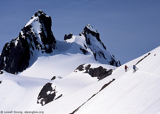
| Traversing from the Overcoat Glacier toward Summit Chief saddle with Chimney Rock in the background, June 2002. (Map, 700kb) |
|
I first visited the Cascade crest between Snoqualmie Pass and Stevens Pass in September 1975. Gary Brill, Bill Chaffin and I spent eight sunny days traversing on foot between Rampart Lakes, near Snoqualmie Pass, and Cathedral Rock, above the Cle Elum River. I celebrated my 19th birthday at the saddle between Chimney Rock and Overcoat Peak (shown in the photo above) and we traversed over the summits of Mounts Hinman and Daniel near the end of our trip. Congress established the The Alpine Lakes Wilderness just a few months later. The public debate over the Alpine Lakes, combined with my experience on this trip, opened my eyes to the importance of protecting wild country in the Cascades. Gary Brill was my first wilderness mentor, and a few years later he introduced me to alpine ski touring.
During the 1980s and 1990s my backcountry skiing interests were focused on the North Cascades. In 1999, my brother Carl joined Martin Volken and three others to ski a route they called "The Snoqualmie Haute Route." This was a horseshoe traverse around the headwaters of the Middle Fork Snoqualmie River. They bushwacked up Hardscrabble Creek to Big Snow Mountain, then followed the divide northeast to their first camp. The next morning they climbed and skied Mount Hinman. Then they skied over the saddle west of Summit Chief Mountain and climbed to the Overcoat Glacier. On their third day, they skied to Iceberg Lake and passed over Chikamin Peak to the saddle next to Huckleberry Mountain. Finally, they followed the Gold-Burntbook Creek divide southwest to Snoqualmie Pass. Carl's description of this trip sparked my interest in skiing through this country, but I decided against doing the horseshoe route. I preferred to cross the mountains from one side to the other. My 1975 route with Gary Brill seemed like a promising ski trip. It offered the opportunity to ski virtually over the summit of Mount Daniel, the highest peak between Snoqualmie Pass and Stevens Pass. The only downside to doing this trip in spring was that the exit might be longer than in summer, since the Cle Elum River road was likely to be snow covered several miles below the end (see map, 700kb). In the spring of 2002, I recruited Bruce Goodson, Joe Catellani and Matt Firth to ski the Alpine Lakes Traverse. That winter the snowpack at Snoqualmie Pass was 130 percent of normal. This enabled us to schedule the trip late in spring, when the weather was more stable and the snowpack more consolidated. We monitored the weather and snow obsessively as the spring progressed and settled on June 1 as our starting date.
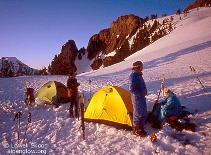
Bruce, Joe and I drove over Snoqualmie Pass from Seattle. We met Matt, who drove from his home in Twisp, near Cle Elum. We drove up the Cle Elum River and parked a car between Camp and Fortune Creeks, about five miles short of the road end. Then we returned to Snoqualmie Pass. We parked at the Commonwealth Basin trailhead and were able to begin skiing immediately. The first obstacle on the trip was the "Kendall Catwalk," a section of the Pacific Crest Trail that was blasted across a rock slab near Kendall Peak in the late 1970s. We found the catwalk largely snow-free, thanks to its southern exposure and warm rock. But the final part of the traverse required steep step-kicking across a snowpatch. Once across the catwalk we found pleasant, mostly level skiing to the shoulder south of Ridge Lake. We traversed the south facing slope above Alaska Lake, but concluded that it was a poor route, exposed to cliffs above the lake. A better route would be to cross the divide north of Ridge Lake to the basin below Mount Thompson and then cross again at Bumblebee Pass, just west of Alaska Mountain. Once over Alaska Mountain, we skied down to Joe Lake and climbed to a campsite at the saddle east of Huckleberry Mountain. The next morning we climbed the west flank of Chikamin Ridge, which had frozen overnight, on crampons. We skied sun-softened snow to Chikamin Lake with great views of Lemah Mountain and Overcoat Peak. Here we joined my 1975 hiking route, which reached this point from Alta Mountain to the south. We traversed northward and descended to Iceberg Lake, then climbed to the Overcoat Glacier. We found a campsite above the east edge of the glacier with a commanding view of the east face of Overcoat Peak and the north face of Chimney Rock. After we set up camp, I took my ice axe and scouted the divide to the northeast. This was the way I had gone in 1975, but I was unsure it would go with snowy conditions (see top photo, above). I traversed carefully above cliffs on skis, sloughing the loose surface snow as I went. Then I removed my skis and kicked steps across steep snow to a rock ramp that accessed the crest beyond. After verifying that the ramp was passable, I returned to camp, somewhat anxious about retracing the route with full packs the following day. On the third morning, Bruce and I skied to Overcoat Peak and I scrambled to the summit. We returned to camp and packed up, then followed the steep traverse toward Summit Chief Mountain that I had scouted the day before. Thanks to my scouting efforts and just the right amount of softening by the sun, the traverse went easier than expected. In just a half-hour from camp we put the difficulties behind us.
From Summit Chief saddle we descended a lovely hanging valley to the north, then rounded a forested shoulder to the head of the Middle Fork Snoqualmie River, just below Dutch Miller Gap. We found the upper reaches of the Middle Fork to be remarkably open compared to the heavily forested Snoqualmie Pass area. After lunch we climbed from La Bohn Lakes to the summit of Mount Hinman. We had hoped to camp high on Mount Hinman to enjoy ski runs on its glaciers, but the weatheradio forecast had changed for the worse. Clouds and rain were expected that night. We decided to press on over Mount Daniel that afternoon. (In June 2013, I returned with Crispin Prahl and David Nicholson to camp on Mount Hinman and spend more time enjoying the area. See photo at right.) Mount Hinman and Mount Daniel are two of the finest Cascade ski summits pioneered by Dwight Watson. In 1937, Watson and Sigurd Hall skied Mount Daniel. One of Watson's pictures from the trip shows Sigurd Hall high on the mountain wearing nothing but undershorts and skis. Today's mountaineers obsess about "going light," but none have topped Sigurd Hall in this respect. In 1944, Watson and four friends skied Mount Hinman from the East Fork Foss River. For years, Hinman's remote summit had tantalized Dwight Watson when viewed from the Stevens Pass ski area. The Foss River approach was a brushy ordeal, but they were rewarded with a beautiful ski run, which Watson captured in an 8mm movie. He later summed up the trip as "twenty hours walking for twenty minutes skiing." In the 1960s, Bob Grant and Jim Whittaker proposed a ski resort on Mount Hinman. In a March 16, 1966 article in the Seattle Post-Intelligencer, they wrote, "Mount Hinman has the possibility of being developed into one of the finest ski areas in the nation." They got Senator Henry M. Jackson interested in the project, but fortunately it never happened. After the North Cascades National Park was established in 1968, the Park Service and Forest Service studied over a dozen sites throughout the Washington Cascades for potential ski area development. Only one, Early Winters in the upper Methow Valley, received serious consideration. Controversy over Early Winters simmered until 1995, when plans for a downhill ski resort were finally abandoned. From the summit of Mount Hinman, we skied huge open slopes to the Hinman-Daniel saddle. We traversed southeast, then climbed southwest facing slopes to the west shoulder of the Lynch Glacier. As we climbed the glacier toward the summit of Mount Daniel, mists from the approaching weather system gave the mountain an Alaskan look. We reached the top around 6:30 p.m. then descended the east glacier to Peggy's Pond. The next day we continued down the snow-covered Cathedral Pass trail to the Cle Elum River road. The road was partly bare (hiking) and partly snow covered (skiing) for five miles to our car. As we drove back to Snoqualmie Pass, clouds enveloped the mountains and it began to rain. Our timing could hardly have been better. --Lowell Skoog
|
||||||||||||||||||||||||||||
|
Previous | Next | Overview - Skiing the Cascade Crest | The Alpenglow Gallery |


