 |

ay 3 – The Valhallas At Last
We awoke in a bed of sun-lit avalanche lilies and soon left camp in eager anticipation of high alpine
scenery. We headed up the Valkyrie Creek valley and by midday had reached the snow-covered Frigga-Baldur
Col that provided access to the Valhallas. Finally, the moment we had anticipated since the trip began!
On the spot my parents had stood 27 years previously, I basked in the spectacular views of Bugaboo-like
peaks adorning the edges of the Geri-Freki Glacier.
In 1980, my parents climbed four peaks in the Valhallas. Theirs were the third ascents of Frigga and
Hugin and the fifth ascents of Baldur and Munin, and my mom was the first woman to summit these four
peaks. Like most peaks in the Olympic Mountains, they are fun but loose Class 3 or 4 scrambles.
 |
 |
|
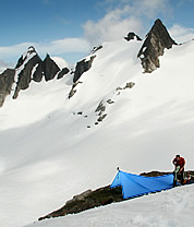
Valhallas camp above the Geri-Freki Glacier just below Baldur. © Steph Abegg Enlarge |
|
 |
I was eager to find the summit registers bearing my parents’ names (which we unfortunately could not
find), so Douglas and I first climbed Frigga, which treated us to a spectacular panorama of the Valhallas
cirque and Mount Olympus to the northeast. In a notch on the ridge at Frigga’s base we found eight feet
of delightfully solid rock, possibly the best in the Olympic Range. Of course it doesn’t go anywhere but
was a fascinating contrast to the usual chossy rock scraped from the sea floor millions of years previous.
After Frigga, we headed for Baldur, which is best climbed from the ridge on the other side of the Geri-Freki
Glacier. On the traverse over, we came across an amazing campsite perched on a heather-trimmed shelf at the
head of the Geri-Freki Glacier, surrounded on all sides by the rocky Valhalla spires. A rare liquid
water source was even nearby. While Douglas took a nap, I climbed Baldur and soon joined him basking in the afternoon
sun at camp and planning the next day’s climbs. Due to the proximity and relatively low relief of the
Valhalla peaks, most of the remaining summits seemed climbable the following day. In particular,
the Class 4 Woden Peak, the highest of the Valhallas at 6,038 feet, and the flagpole summit of Loki Spire looked like fun.
However, during the night the clear skies were replaced by clouds and drizzle. We pitched the
tent for the first time, commenting that ‘normal’ Olympic Mountain weather had finally arrived.
Unfortunately, the poor weather meant we would have to forgo any more climbing in the Valhallas,
since the ambitious schedule of our trip would not allow a day to wait out the weather. I was
disappointed and kicked myself all the next day for not bagging at least one more peak that
previous gorgeous afternoon. All the more reason to return to the Valhallas!
Day 4 – From the Valhallas to Hubert Glacier
Since little guidebook information is available for this unfrequented area,
we had planned on visually route-finding our way along the ridge from the Valhallas
to Mount Olympus. However, visibility was down to a couple hundred feet, so we
decided to try a new technique. Looking at the digital photos on the back of my
camera from the summit of Frigga the previous day, we traced a
feasible route along the ridge towards Mount Olympus across the Hubert Glacier and
up to the Mount Tom ridge line where we would intersect an established climbing route.
We had initially planned to follow my parents’ old boot-tracks under Athena and
approach the summit from the south. But given the visibility and the fact that
we could not see this area in my photos, we decided to cross the Hubert
Glacier instead. This decision was potentially risky, since we didn’t even know
if Hubert Glacier was a viable route.
 |
 |
|
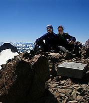
On the summit of Mount Olympus. Enlarge © Steph Abegg |
|
 |
Fortunately, the ridge between the Valhallas and Mount Olympus still held substantial
early-summer snow, which made for easy travel towards Hubert Glacier. However, liquid water was difficult
to find. At one point, we found water streaming down a cliff face and Douglas came up with an ingenious way
to collect water using a plastic map case.
By mid-afternoon, the weather began improving and we took advantage of breaks in the
clouds to take photos of our proposed route across the Hubert Glacier. A continuous path of snowfields appeared to lead to the Mount Tom ridge line, the first step in our journey the next day. We embraced our giddy suspense. Would
our chosen path actually work, or would we be denied by an insurmountable cliff band
or gaping bergshrund?
We found a nice campsite on a knoll at the base of the Hubert Glacier. The only
downside was its 15-degree slope. Given the size of the knoll and my rate of slide,
it’s a good thing I woke every hour to pull myself back to the head of the tent.
Day 5 – Crossing over Mount Olympus
We had taken four days to reach Mount Olympus, not the fastest approach by any means.
On the other hand, few people have ever seen the west face of Olympus under which we were
camped. On Day 5, we would hopefully climb the namesake peak of the Olympic Mountains.
Either because of our anticipation or the sloping tent-spot, we were crunching up the
glacier before the sun rose. The sky had not one cloud, as if the storm
had never happened.
We crossed the Hubert Glacier and weaved upwards towards the Mount Tom ridge line Around
each bend, I expected our way to become hopelessly blocked by a polished cliff face or a
gaping crevasse. As we climbed higher and higher, the suspense ascended with our tracks
and we became certain that the mountain would deny us victory. But in the end, the line we had
scoped was a good one and we popped up on the ridge line by mid-morning.
Elated, we dropped onto the Blue Glacier and intersected the standard climbing
route of Mount Olympus. Seeing human tracks felt odd after being in such untouched
wilderness, but was comforting after the intense route-finding of the past few days.
We soon arrived at the base of the rocky summit-block — almost there!
 |
 |
|
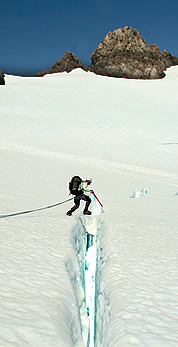
Doug jumping a crevasse on the Blue Glacier. Enlarge © Steph Abegg |
|
 |
The final part of Olympus’s summit climb involves a pitch of 5.4 rock. We scrambled
up easily and were soon standing at the highest point in the Olympics ogling the 360-degree
view of the entire Olympic Peninsula. This summit was more than just a topographic high point for
both of us. Douglas had grown up on the Peninsula and had learned his passion for the mountains
in this range. And I, who had been weathered off Olympus during a family vacation in 2004,
was glad to add another summit panorama to my collection. We relished having the summit to
ourselves, thankful for the poor weather that had kept other climbers away.
After a well-earned reprieve, we descended southeast towards the Hoh Glacier. We
scampered below the Middle and East Peaks of Mount Olympus. I convinced Douglas to jump a
crevasse, hoping he wouldn’t notice my ice axe lying lazily in the snow as my fingers toyed
with my camera. A new lightness was in our steps — the first half of our trip had come
off with flying colors, and the weather had been better than we had ever hoped for. The second
half of the trip would be easy, on less committing terrain. In our excitement, we circled all
the way around the three summits of Olympus to the pass overlooking the South Fork Hoh, giving
us a birds-eye view of our last camp and the ridge traverse of the day before. We turned,
trotting down the Hoh Glacier on an easy and quick course to Camp Pan to stay the night.
Given the improving weather, we were surprised to encounter no climbers at Camp Pan.
We also saw no recent boot tracks, suggesting that the Hoh Glacier approach is not frequented.
|

|
| Geology |
The Olympic Mountains rose from sediments from the sea. From 18 to 57 million years ago, sediments accumulated on the ocean floor. Over time they
compressed into shale and sandstone. Meanwhile, fissures opened under the water
and lava emerged, creating huge underwater mountains and ranges called seamounts.
About 35 million years ago, the plates that formed the ocean floor gradually subducted beneath the continental land mass. The basalt and sedimentary rocks
on the sea floor were scraped off the subducting Juan de Fuca plate and jammed against the
mainland, creating the forerunner of today’s Olympics. As a
result, the Olympics are a curious mélange of basaltic and oceanic sedimentary rock (not ideal for climbing, since it crumbles easily).
Radiating out from the center of the range, streams, and
later a series of glaciers, carved peaks and valleys, creating the beautiful, craggy landscape we
know today. Ice Age glacial sheets from the north carved out the Strait of Juan Fuca and
Puget Sound, isolating the Olympics from nearby landmasses. |
| |
| |
|
 |


