|
|
||||||||||||
 |
|||||||||||||
 |
|||||||||||||
|
|||||||||||||
|
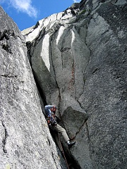
In the summer of 2004, Dan Cappellini, Kevin Newell and I climbed a quality rock route on The Blockhouse. The route starts at the lowest corner of the west face, a short way up the gully between The Blockhouse and the Monkey’s Head. Pitch 1 (5.10) takes an obvious right-facing corner. The next pitch (5.10) is a large flare/off-width to a ledge. Pitch 3 (5.9) follows a left-facing corner and face cracks and pitch 4 (5.9/10) continues up finger and hand cracks. Pitch 5 completes the climb with more 5.9-ish climbing to the north ridge and around some towers to the summit blocks. Pitches 4 and 5 were longer than 60m and required some simul-climbing. The route is approached via Hook Creek and over the ridge north of The Blockhouse. Descend by rappelling the Cotman East Face route. We recommend nuts and cams to five inches. III, 5.10 -Rolf Larson Olympic Mountains, Hurricane Ridge to Mount Constance, Ski Traverse In two trips, during 2008 and 2009, Eric Jackson and Mary Goodfellow completed an outstanding ski traverse through the NE Olympic Mountains. In mid-May 2008, the pair skied from Hurricane Ridge to Royal Basin over four days. Starting at Hurricane Ridge, their route followed the Obstruction Peak road and continued along the ridge to the south, then descended into Grand Valley before climbing to Grand Pass. From the pass, the party traversed and descended into the Lillian River headwaters then climbed the remnant Lillian Glacier to Peak 6728ft. They descended the SE flank of this peak then climbed back up to the ridge to the south. They traversed the SW flank of this ridge at about 6300ft to Cameron Pass. After descending into Lost Basin they climbed eastward to Point 6956ft east of Mount Cameron. From here they descended the NE-facing Cameron Glaciers and climbed to a pass to the east. They descended toward Cedar Lake and climbed out of its basin to the SE. The route continued eastward below the north side of Gray Wolf Pass between 5500ft and 6000ft, eventually climbing to the saddle between Peak 7070ft and Mount Johnson. They descended the glacier to the north then climbed SE over Surprise Pass and skied down into Royal Basin. They hiked out Royal Creek.
In mid-May, 2009, the pair returned to Royal Basin to complete the trip as originally envisioned. Crossing from Royal Basin into Deception Basin, they climbed to the saddle just east of Mount Mystery. They skied down to about 5000ft in Heather Creek basin then ascended south to the ridge between points 6514ft and 6666ft. They descended eastward below Point 6666ft and ascended to the ridge east of Sunnybrook Meadows and followed it to Constance Pass. The descended Home Creek to a point just west of Warrior Peak. Ascending east, then south, they crossed the col between Inner Constance and Desperation Peak and skied down to Lake Constance. From the lake they climbed east and crossed a shoulder to the head of Bull Elk Creek. They traversed the head of Bull Elk Creek a short distance to the divide at the western head of Tunnel Creek. The skied down to Tunnel Creek and hiked out to the road. Glacier Peak, Cool Glacier Headwall, Ski Descent On July 6, 2008 we skied from the summit of Glacier Peak down the main couloir of the Cool Glacier Headwall. We had approached from White River trailhead two days earlier, following the White River before heading up Lightning Creek. The approach involved three creek crossings and chest-high brush on the “trail” with the worst stretch between Thunder and Lighting Creek. We camped along the Kololo Peaks divide at 7140ft spending a day there in the rain. On the 6th, we ascended the Honeycomb Glacier, traversed the Suiattle Glacier, and ascended the Gerdine and Cool Glaciers to the SW gullies and the summit. Our ski descent of the Cool Glacier Headwall had nearly perfect corn snow. The 45-degree-plus couloir begins with a steep roll and finishes with a wide runout. Below the couloir we traversed skier’s left to avoid the bergschrund. Terrific spring ski conditions brought us back to our camp for the long hike out. -Monika Johnson and Ryan Lurie Mount Cashmere, NE Face, Ski Descent On April 5, 2009, I skied the NE Face of Mount Cashmere, approaching via Pioneer Creek. For years this face has captured my attention while driving Highway 2 down Sunnyslope Hill west of Wenatchee. As winter fog gives way to the blue skies of spring, the snow pyramid of Cashmere contrasts with the green orchards of the Wenatchee Valley. It’s my favorite time of year, when I can skin up softening corn on the south slopes of the peak and ski cold powder on the north.
My decision to try the NE Face was spontaneous, based on the conditions I found that day. The slopes above Pioneer Creek were softening into gloppy corn as I climbed. When I reached the col east of Cashmere’s main summit, the colder NE Face looked quite possible. An hour later I rested on the sharp summit in an icy breeze. It was still winter up there—a far cry from the warm valley I’d left behind. Tightening my boots, I made a cautious turn down the face. Another careful turn followed, and I gradually gained enough confidence to link the arcs in a gentle rhythm. The slope steepened significantly, but with powder this good, skies this clear, and air this still, the vertical fell away without worry, weaving around small cliffs and rock bands. At the bottom I caught my breath, relieved but also a bit disappointed not to share the euphoria of the descent with a partner. With skis on my pack, a sure sign of spring, I was soon back down the dry Eightmile Road to my car. -John Plotz Columbia Peak, East Face, ski descent In April 2009 my dog Vagabond died of old age. He and I had many adventures together. Soon after his death I enlisted Jason Hummel, Josh Hummel, and Christy Kinney for an adventure in Vag’s honor. Columbia Peak’s East Face first caught my attention in 2001 while I tossed sticks to Vagabond along the shore of Blanca Lake. The route is beautiful—the bottom third traverses above a significant cliff band, the middle third is a couloir/face perched directly above a high point in that band, and the top third is a hanging snowfield with several thousand feet of exposure. On April 26, Jason, Josh, Christy and I met in Monroe at 1:00 a.m. We drove over recently plowed Jack Pass and hiked to Virgin Lake by sunrise. Soon we were crossing Blanca lake under broken clouds. We discussed the deteriorating conditions as we climbed. Below the final summit snowfield, Josh and Christy decided to wait at a safe zone while Jason and I climbed to the top. The final slope was better than I could have dreamed. Steep, sustained, dramatic, exposed. Jason allowed me first turns, and then bravely took over for the delicate traverse along the bottom of the hanging snowfield to where Josh and Christy were waiting. We all enjoyed the ski down to the lake, where we celebrated with a nap in the afternoon sun. I thought about Vag frequently, and about how he used to look at me when content. It was with those eyes that I gazed upon the slopes we had skied. I highly recommend this route. -Ryan Lurie
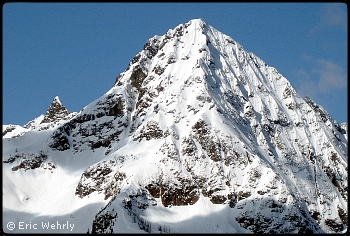
Greybeard Peak, East Face, New Route and Ski Descent While climbing Mount Hardy to ski its NE couloir, I couldn’t help but gawk across Highway 20 at the appealing East Face of Greybeard Peak. On May 16, 2009, Dan Helmstadter and I climbed and skied this beautiful peak (on maps it appears as the eastern terminus of Ragged Ridge, elevation 7965ft, east of Easy Pass). We started climbing very early after a solid freeze, and at the base availed ourselves of a 500-ft NE-facing couloir to gain a series of ribs and ultimately the East Face proper Runnels in the couloir initially made for ready sticks with axes and crampons, but abruptly morphed into chunder-wonder variability. The climbing on the ribs and face above was often steep and entertaining; I recall at one point left hand to rock hold, right hand to axe in snice, left foot post-holed, and right foot kicked into ice—what was next was a guess. Route-finding slowed us down a bit, as did two crampon failures for Dan, which he handily repaired. Luckily, clouds kept the sun at bay, urging us upward. Summit views into the North Cascades were astounding. We had arrived before 8 a.m., and decided to hope for the sun to break through lifting clouds and soften the icy patina found on much of our climb. When the mid-May sun finally broke through at 11 a.m., it was immediately forceful, and our worries quickly turned from too-crusty snow to too-soft. To our relief, we found mostly soft and sluffy spring snow on steep slopes, making for enjoyable skiing. Low on the descent, we down-climbed a short rocky section. Finally, we jumped a little step to finish the face, and contoured along a ridge feature to drop into the basin below the North Face. This is an invigorating climb and ski on an aesthetic peak, one I hope to repeat soon. -Eric Wehrly (The opening photo on this page shows Greybeard Peak from the east. See topo.)
Chiwawa Mountain, NW Face of East Peak, Ski Descent This tour began at the Wenatchee Valley Museum in the spring of 2008, during a slide-and-movie presentation by Lowell Skoog. Several pieces of movie footage stood out for me, chief being the scenes of Chuck Hessey and friends skiing near Lyman Lake. Maybe it was their runs on the huge slopes of Cloudy and Northstar Peaks or the incredible shots of the North face of Fortress. Either way, I was hooked. I journeyed by car, boat, and school bus to the quiet and nearly deserted village of Holden.
I humped my gear up to lower Lyman Lake the next day. It was my first-ever trip to the area, and I was stunned and a bit overwhelmed as to what to ski first. I resolved merely to do some “scouting” the next morning (May 17, 2009). I got a late start under blue skies and rapidly warming temperatures. I skinned across the Lyman Lakes and up to Spider Gap. From there, I held my breath and skinned beneath the sagging cornices that loomed over Spider Meadows. I reached a break in the ridge where I could gaze into the Chiwawa drainage towards Trinity. From this stance I marveled at Glacier Peak and the immense North Face of Buck Mountain. Having no real objective in mind, I climbed to the nearest high point and decided to drop down the north side of Chiwawa’s East Peak, because I sure as hell was not going to reverse my route and ski under the cornices again, now that the heat was blistering. I dropped in and skied steep, wonderful, spring powder down to upper Lyman Lake, where I rested, took my boots off and watched a significant avalanche cycle send sloughs rumbling down slopes all around me. This became the pattern of my four days up there, erasing any sign of my descent on the NW Face. -John Plotz Hozomeen Mountain, North Peak, NE Face Ski Descent
On May 16-17, 2009, Sky Sjue, Andy Traslin and I climbed and skied the NE Face of Hozomeen Mountain’s North Peak. We began our voyage in Skagit Valley Provincial Park, B.C. The Skyline II trail led us into Manning Provincial Park and to the junction with the Hozomeen Ridge trail. We wandered along the friendly ridge well after darkness fell, and finally hit the sack a few hundred meters from the U.S. Border. When dawn broke, we staged our assault on the NE Face. The day was warm and the snowpack had yet to fully consolidate and as a result we narrowly dodged a few minor wet sluffs as we climbed through the 20-ft ice and rock step at mid-height. Motivated by deteriorating conditions, we gained the top quickly, snapped summit shots, and tried to skip stones on Ross Lake an impressive 6,400ft below us. We descended the face on skis but resorted to downclimbing the rock step then skied the sticky-icky moraine slopes below before regaining the ridge, Canada, and our camp. The descent was a familiar exercise in pack-laden downhill trail running spurred by the promise of hand-shaved noodles at Sha Lin Noodle House in Vancouver. We were heartbroken to find we were 30 minutes late for noodles upon our arrival in the city, and thus had to consider the trip a failure. -Drew Tabke |
|
|
|||||||||||||||||||||||||||||||||||||||||||||||||||||||||||||||||||||||||||||||
| Continued 1 | 2 | 3 | 4 | 5 | Next>> |
|||||||||||||||||||||||||||||||||||||||||||||||||||||||||||||||||||||||||||||||||
| ©2010 Northwest Mountaineering Journal | |||||||||||||||||||||||||||||||||||||||||||||||||||||||||||||||||||||||||||||||||
| Site design by Lowell Skoog |
