|
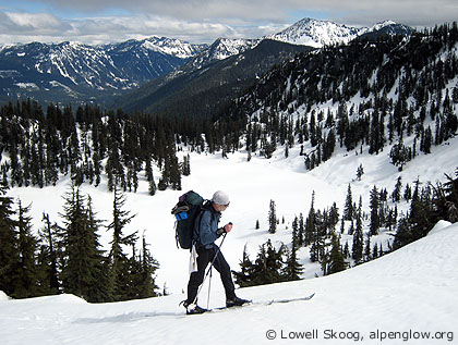
| Paul Ekman traverses toward White Pass on the first day, April 2007. Indian Head Peak rises in the background. (Map, 900kb) |
|
South of Glacier Peak, the Cascade Crest gradually changes from a world of rock and ice to a landscape of forests, parklands, and rounded summits. Between White Pass and Stevens Pass, the Pacific Crest Trail runs close to the divide, while farther north it has been necessary to locate the trail miles from the crest. Skiing from White Pass to Stevens Pass means following the Crest Trail. This is not as simple as it sounds, because deep snow buries the trail, making slopes that are enjoyed by hikers sometimes difficult and dangerous for skiers.
The mountains above the White River and Little Wenatchee River were home to Dale Allen. Born in 1910 to settlers near Lake Wenatchee, Allen lived and skied in these mountains all his life. During the Great Depression, he survived by trapping. "That's the way to make a living in the winter," he later told historian Harry Majors. "When those banks went broke, I stayed in the mountains. There was no work. I'll tell you, I could eat by trapping." Allen was a supervisor for the State Game Department for many years. With Walt Anderson of the Forest Service, he made many long ski trips in the North Cascades from the 1930s through 1950s. In about 1940, Allen and Anderson skied over the mountains from Darrington to the Little Wenatchee River, covering much of the country I would later ski. Allen spotted a grizzly bear on this trip, "the only one I ever saw in the mountains." Allen and Anderson also made long winter trips in the Pasayten wilderness, covering as much as 60 miles in a week and enduring sub-zero Fahrenheit temperatures with minimal equipment. Allen later told Chester Marler that he made these trips "for the simple pleasure of going, just being out in nature ... the beauty of the country ... I'm not sure exactly what being in the mountains does to you, but it does something, and it's wonderful," he said. When I decided to try to complete the Cascade Crest on skis after my brother Carl died in 2005, the section from White Pass to Stevens Pass was the longest remaining segment. The distance from the North Fork Sauk trailhead to Stevens Pass is about 45 miles. Snow blocking the road below the trailhead lengthens this distance to nearly 50 miles. Once you set out along the crest, there are no simple exit routes. So the route has a feeling of commitment. Paul Ekman and I settled on a four-day period over Easter weekend, 2007, to attempt the trip (see map, 900kb). We left Seattle on April 6 and drove to the North Fork Sauk River. This area holds snow at a remarkably low elevation. We were stopped by snow on the road only 1800 feet above sea level. We had to walk several sections of road, but fortunately we were able to ski most of the four-plus miles to the Sloan Creek campground.
The North Fork Sauk trail offered the usual obstacles of a North Cascade valley in spring -- rough and rotten snow, bare spots that required us to take off and put on our skis repeatedly, fallen trees to crawl over, under or around, and tricky creek crossings. The farther up the trail we went, the less we wanted to revisit these obstacles, even if the weather turned bad. We became ever more committed to continuing onward. We worried about avalanche conditions on the south-facing slopes leading to White Pass. The initial steep climb out of the valley was hot with terribly rotten snow. But the snow stability was reasonably predictable, and by climbing among small trees we never felt exposed to significant danger. Fortunately, the snow conditions improved as the snow became deeper and the slopes less steep. After a long, hard day, we finally pitched our tent at the pass. On the second day we awoke to advancing clouds and an ominous red dawn. The weather looked worse than we had expected. We some trepidation, we broke camp after sunrise and set out along the crest, knowing there were no good bailouts for thirty miles. Light rain started falling around 9 a.m., but fortunately it didn't last. We slowly ticked off the landmarks -- Indian Pass, Kodak Peak, Dishpan Gap, Wards Pass, Skykomish Peak, and finally Cady Pass. New snow that had fallen earlier in the week was wet and rather sticky, but the trail-breaking was reasonable and the only hazard was minor sloughing in places. We originally planned to camp at Cady Pass, but decided to push a few more miles over Saddle Gap to a camp near Fortune Ponds. On the map this section looked like a monotonous forest. But in reality we found enchanting old trees and glades that offered views of distant peaks. I was charmed by the forest, a response that surprised me, having been obsessed with skiing alpine terrain for so many years. Clouds engulfed our camp that night and light rain fell. On Easter morning, our third day, we awoke to fog and mist. Paul told me that it was his 55th birthday. He said he couldn't think of a better way to spend it than in the mountains on this trip.
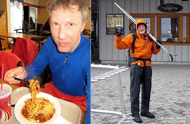
We skied to Pear Lake and Wenatchee Pass in fog but were encouraged by breaks in the clouds as we traversed over Grizzly Peak to Lake Janus, our intended campsite that night. Threatening clouds began gathering again after lunch. We decided to push on beyond Lake Janus and we stopped below Union Gap in mid-afternoon as it began to rain. After a spell of steady rain, my ultralight tent began to leak. Drips landed on my forehead as I lay listening to the rain. This would never do, so I crawled out of the tent during a lull in the rain and rigged a homemade rainfly using a garbage bag. The rain continued overnight. We discussed the idea of bailing out via Smith Brook to Highway 2 if the rain continued the next day, but neither of us really wanted to do that. After a night of fitful sleep, I heard the rain change to snow around 4 a.m. The fourth and last day offered weather that was tolerable, if not ideal. It snowed continuously but not too hard as we skied to Lake Valhalla. A few inches of cold, new snow over a rain-soaked base produced a snow surface that was like a mixture of spun glass and cottage cheese. We encountered the most extreme icing conditions I've ever seen. Paul compared breaking trail in the sticky snow to walking in deep-sea diving boots. We stopped to rub wax on the tops, bottoms, sides and edges of our skis to prevent snow from sticking. It occurred to me that under such conditions, ski wax could actually be a life-saver. Eventually we reached the Great Northern railroad grade and skied to the Stevens Pass parking lot, arriving shortly after noon. After decades of ski trips that ended at trailheads far up old logging roads, I loved the idea of ending this trip at an operating ski area. As soon as we removed our skis, we headed straight for the Stevens Pass lodge and I ordered a hot lunch. The pasta I bought looked so good that Paul decided against eating trail food (an idea that had never crossed my mind!) and he ordered a hot lunch too. We ate quickly and headed back out to the highway to watch for the bus. Right on schedule, at 1:55 p.m., we flagged down the daily Trailways bus from Wenatchee to Seattle. It seemed a uniquely civilized way to end our trip. Paul's wife Jean picked us up at the Seattle bus station and we spent the rest of the evening retrieving my car at the North Fork Sauk River. --Lowell Skoog
|
||||||||||||||||||||||||||||
|
Previous | Next | Overview - Skiing the Cascade Crest | The Alpenglow Gallery |